|
|
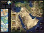 | National Geographic Cartographic ExhibitionNational Geographic Society Cartographic Exhibition featuring one hundred spectacular, global, regional and topical maps of our world from the NGS archives. Come see our world through the eyes of National Geographic Cartographers. Click here to learn more about the National Geographic Cartographic Exhibition |
|
|
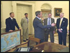 | Keynote Speaker: National Geographic Chief CartographerChief Cartographer and Executive Vice President of National Geographic Maps, Allen Carroll will take us on a tour of ninety years of map making at the National Geographic Society and show us what new and exciting plans the society has for the future. Click here for Allen Carroll's Biography |
|
|
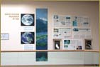
 | National Geographic "Ninety Years of Cartography" Display20 x 30 foot, twelve panel National Geographic Society "Ninety Years of Cartography" Display as seen at the 2005 National ESRI Users Conference in San Diego California. |
|
|
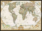
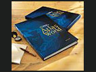 | National Geographic Atlas Sale and Book Signing Chief Cartographer and Executive Vice President of National Geographic Maps, Allen Carroll will be conducting a book signing of the exciting new eighth edtion National Geographic Atlas of the World at 1:30 pm immediately following his presentation. His book will be available for sale on site in this year's GIS Day Store along with many other exciting books and Geo-merchandise. |
|
|
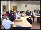 | New Hampshire ArcUsers Group Fall MeetingThis year's GIS Day Conference is hosting the New Hampshire ArcUsers Group Fall Meeting during its afternoon professional sessions. GIS Day Vendors will be presenting the latest technologies to the group in 30 minute presentations. Open to the pubic. See the GIS Day Agenda for a list of scheduled presenters. |
|
|
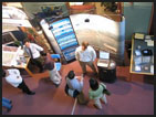
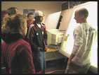
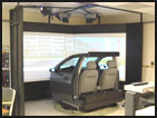 | Car Simulator: Drive Through a Virtual Map Come see the Project 54 full size driving simulator and see how researchers use this tool to simulate real driving environments within a virtually mapped world to study human interactions with real vehicles under a series of circumstances. |
|
|
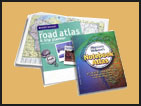 | Atlas Gift Give AwayAll GIS Day 2005 registered professional participants will receive a FREE Rand McNally Road Atlas and Trip Planner just for attending the days's events while supplies last. All registered visting high school students will receive a complimentary Merriam Webster Notebook World Atlas while supplies last. |
|
|
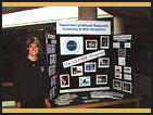
 | Geo-Spatial Science Map and Poster GalleryOver fifty regional Geo-Spatial Science professionals will display maps and posters featuring their works from science, urban planning, emergency management, government, resource management, education and industry. Click here for a full listing of all invited Map and Poster Presenters. |
|
|
 | Geo-Science University and College Presentations and College FairStudents, the public and professionals alike will be hosted to this years GIS Day 2005 Geo-Science College Fair featuring reepresentatives and curricula from many regional college, university, and professional Geo-Science departments. Click here for a full listing of all invited Geo-Science College Fair Presenters. |
|
|
 | Professional Vendor HallAll guests to this year's GIS Day events will be hosted to a professional vendor hall exhibition which will feature representatives from many of the Geo-Spatial Science industry's leading hardware, software, consulting service, and data providers. Click here for a full listing of all invited Vendor & Data Providers. |
|
|
 | Professional Vendor and Data Provider Showcases and PresentationsThis year's GIS Day 2005 guests will be hosted to professional vendor showcases and presentations featuring national Geo-Spatial Science hardware and software providers, Geo-Spatial Science data providers, and Geo-Spatial Science consulting firms. Click here to see the full Agenda of Presentations. |
|
|
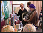 | GIS Day StoreThis year's GIS Day 2005 Store will feature Geo-merchandise products from many leading map, atlas, globe, compass, navigational software and GPS companies. Click here to see all invited GIS Day Store Retailers. |
|
|
 | Institute for the Study of Earth, Oceans, and Space Science Exhibits.These exhibits include the EOS Earth Systems Research exhibit and the EOS Solar Science exhibit. These exhibits contain maps, photos, satellite imagery, and dioramas which focus on earth systems science and environmental change from the depths of the oceans to the heights of the continents, to the limits of space. |
|
|
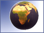 | 3 1/2 Foot Diameter Satellite Image Globe of the WorldThis globe built at the University of New Hampshire Laboratory for Remote Sensing and Spatial Analysis features beautiful NASA MODIS and NOAA AVHRR satellite imagery. This imagery is so clear that you can see individual glaciers in Antarctica and some reefs below the oceans. |
|
|
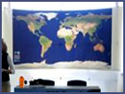 | 9-Foot Satellite Image Map of the WorldThis true color NASA Blue Marble MODIS composite satellite image map of the world shows us a unique perspective of our world as never seen in previous decades. The construction of this high resolution, fine detail satellite map of the world was made possible only in recent years because of advances in satellite imaging technologies and advances in computer storage and processing power. |
|
|
 | Hands on GIS/RS Technology TourThis year's GIS Day 2005 events will feature hands on tours of Complex Systems Research Center's Laboratory for Remote Sensing and Spatial Analysis where everyone will be given an opportunity to try their hand at GIS and digital mapping. |
|
|