Geo Technologies: GIS, GPS, and
Remote Sensing

 Geographic Information Systems (GIS)
A geographic information system (GIS) is a computer-based tool for mapping, managing, analyzing, and displaying data that has a spatial or geographic dimension. By combining standard database query and analysis with mapped information, GIS provides a powerful tool for planning, management, and decision making for all governmental levels as well as the private sector.
Global Positioning Systems (GPS)
Global Positioning Systems (GPS) use a constellation of satellites supported by the US Department of Defense to provide locational information. GPS can be used to determine the location of roads, trails, historic structures, or any other features found on the landscape. Information collected with a GPS unit may be combined with other types of geographic data using GIS technology.
 Remote Sensing
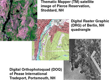
Remote sensing is the process of measuring and observing phenomena on the earth using remote instruments, including airborne cameras and satellite-based sensors. Sensors mounted on these platforms typically collect data as images, which are processed by analysts who interpret the data, extract information, and use it to answer specific questions. The results of these processes are often integrated into GIS databases as individual data layers.


|